fosstodon.org is one of the many independent Mastodon servers you can use to participate in the fediverse.
Fosstodon is an invite only Mastodon instance that is open to those who are interested in technology; particularly free & open source software. If you wish to join, contact us for an invite.

Administered by:

Server stats:

10K
active users

#webgis

1 post1 participant0 posts today

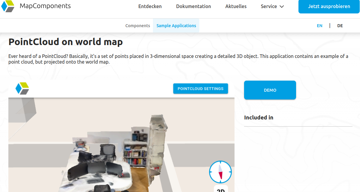
Multi-Tab – Rethinking GIS with MapComponents!

Our Multi-Tab demo shows how MapComponents visualizes geospatial data in a table and on a map across synced browser tabs.

🔹 Real-time sync – Selection in one view updates the other
🔹 Powered by PWAs – Uses the Broadcast Channel API for seamless communication
🔹 Perfect for multi-monitor setups – A desktop GIS experience in the browser

👉 Try it now: catalogue.mapcomponents.org/de

WASM (WebAssembly) is not directly a topic of MapComponents itself, but we do use it together.

In one of our projects we created a very interesting solution to use a C++ script with MapComponents to compute a most complex routing request with absolutely amazingly low calculation costs.

Our colleague Martina Alzueta wrote a blog article about our experiences with using WASM in MapComponents -> wheregroup.com/blog/details/we

wheregroup.comWebAssembly: Revolutioniere Web-GIS mit unbegrenztem PotenzialMartin Alzueta zeigt, welche Möglichkeiten WebAssembly (WASM) bietet, um GIS-Anwendungen performanter, skalierbarer und flexibler zu gestalten.

Do you work with large data sets that span multiple columns? At the same time you need to see the location of this data on a map?

can help you with this in a very convenient way, using two separate browsers, each of which can be placed on a different monitor.

Both browsers can still communicate with each other. Selecting a dataset in the table will highlight and zoom the dataset on the map. The table can also show only the data currently visible on your map.

Did you know that there is an extensive documentation on GitHub storybook of all the components of MapComponents.

mapcomponents.github.io/react-

Not only can you try each component individually, but you can also learn all the configuration attributes and manipulate them directly to see the effect on the map.

For example, in the new ogc api: feature components, you can easily change the amount of features initially displayed on the map via ogcApiFeatureParams.

The point cloud component of MapComponents is now able to adjust the view on the fly.

Do you have some point clouds of a factory console with pipes and valves overlapping each other? Now you can control the size of the points or the colour of the elements to make the 3D visualisation more workable for you.

The following example of our office was achived with a mobile phone recording. easily and quickly done in real position on the map with .

As well as creating new features, we are constantly improving existing ones.

One of the most recently developed components is the one for animating objects on the map: we have an example on mapcomponents.org for the real position and movement of ships in the Baltic Sea.

Now you can select the live data for the actual speed (whether moving or at anchor). Try it here: catalogue.mapcomponents.org/en

Available on GitHub: github.com/mapcomponents/react

So much has happened in the last 3 months :) We have released many exciting tools for 3D on web maps or multi-screen working - like the "PointCloud on World Map" or the "3D Tiles Layer Demo". And quite impressive (at least technically, if not visually) is the "Multi-Tab Demo".

1. catalogue.mapcomponents.org/en
2. catalogue.mapcomponents.org/en
3. catalogue.mapcomponents.org/en

All open source and available on Github: github.com/orgs/mapcomponents

🌍 Rejoignez GISCAN – Développeurs & Spécialistes SIG recherchés !
Nous recrutons des experts en SIG et développement Web GIS pour un projet d’envergure.

#SIG #OGC #PostGIS #QGIS #WebGIS #Geospatial #Python

---
🌍 Join GISCAN – We’re Hiring GIS Developers & Specialists!
We are looking for GIS and GIS development experts to join our team for an exciting project!

📩 Apply now by sending your CV and cover letter to contact at giscan dot com or reach out to us on LinkedIn.

linkedin.com/posts/giscan_sig-

www.linkedin.comGISCAN on LinkedIn: #sig #ogc #postgis #qgis #webgis #geospatial #docker #python #metadata…🌍 Rejoignez GISCAN – Développeurs & Spécialistes SIG recherchés ! 🚀 Nous recrutons des experts en SIG et développement Web GIS pour un projet d’envergure. 🔹 Profils recherchés : ✔️ Maîtrise du logiciel QGIS et de la gestion des données spatiales ✔️ Bases solides en Python, SQL, JavaScript, CSS et HTML ✔️ Expérience avec GeoServer, PostgreSQL/PostGIS, OpenLayers, Leaflet ou QGIS Server ✔️ Bonne connaissance des services Web cartographiques (WMS, WFS, WCS) ✔️ Compétences en déploiement serveur (Cloud, Proxmox, Docker, Singularity, Kubernetes) appréciées ✔️ [Optionnel] Expérience en acquisition de données terrain (Drone, GPS, capteurs IoT) ✔️ [Optionnel] Connaissance des métadonnées (ISO 19115, ISO 19139) 📍 Lieu : Maurice (Télétravail ou hybride possible) 📅 Durée : 1 an, avec possibilité de prolongation 🔹 Pourquoi nous rejoindre ? ✨ Un projet stimulant dans un domaine innovant 💡 L’opportunité de travailler avec les dernières technologies SIG 🌎 Un environnement de travail flexible et dynamique 👉 Passionné(e) par le SIG et les nouvelles technologies ? Rigoureux(se) et prêt(e) à relever des défis ? Nous voulons vous rencontrer ! 📩 Postulez dès maintenant en envoyant votre CV et lettre de motivation à contact at giscan dot com ou contactez-nous sur LinkedIn. #SIG #OGC #PostGIS #QGIS #WebGIS #Geospatial #Docker #Python #Metadata #Cloud #Télétravail #Recrutement — 🌍 Join GISCAN – We’re Hiring GIS Developers & Specialists! 🚀 We are looking for GIS and GIS development experts to join our team for an exciting project! 🔹 Who we’re looking for: ✔️ Proficiency in QGIS and spatial data management ✔️ Solid skills in Python, SQL, JavaScript, CSS, and HTML ✔️ Experience with GeoServer, PostgreSQL/PostGIS, OpenLayers, Leaflet, or QGIS Server ✔️ Strong understanding of web mapping services (WMS, WFS, WCS) ✔️ Knowledge of server deployment (Cloud, Proxmox, Docker, Singularity, Kubernetes) is a plus ✔️ [Optional] Experience in field data acquisition (Drones, GPS, IoT sensors) ✔️ [Optional] Understanding of metadata standards (ISO 19115, ISO 19139) 📍 Location: Mauritius (Remote or hybrid work possible) 📅 Duration: 1 year, with possible extension 🔹 Why join us? ✨ Work on a cutting-edge and impactful project 💡 Opportunity to use the latest GIS technologies 🌎 A flexible and dynamic work environment 👉 Are you passionate about GIS and technology? Detail-oriented and eager to take on new challenges? We’d love to hear from you! 📩 Apply now by sending your CV and cover letter to contact at giscan dot com or reach out to us on LinkedIn. #GIS #OGC #PostGIS #QGIS #WebGIS #Geospatial #Docker #Python #Metadata #Cloud #RemoteWork #Hiring

The @mapbender team is happy to announce the release of the 4.1.0 rc1 on 2025-01-30! 🗺️

We would like to call for testing the release candidate for one week.
Read more at: 👇🏻
lists.osgeo.org/pipermail/mapb
In February 2025 we plan to publish the final version 4.1.0.
mapbender.org

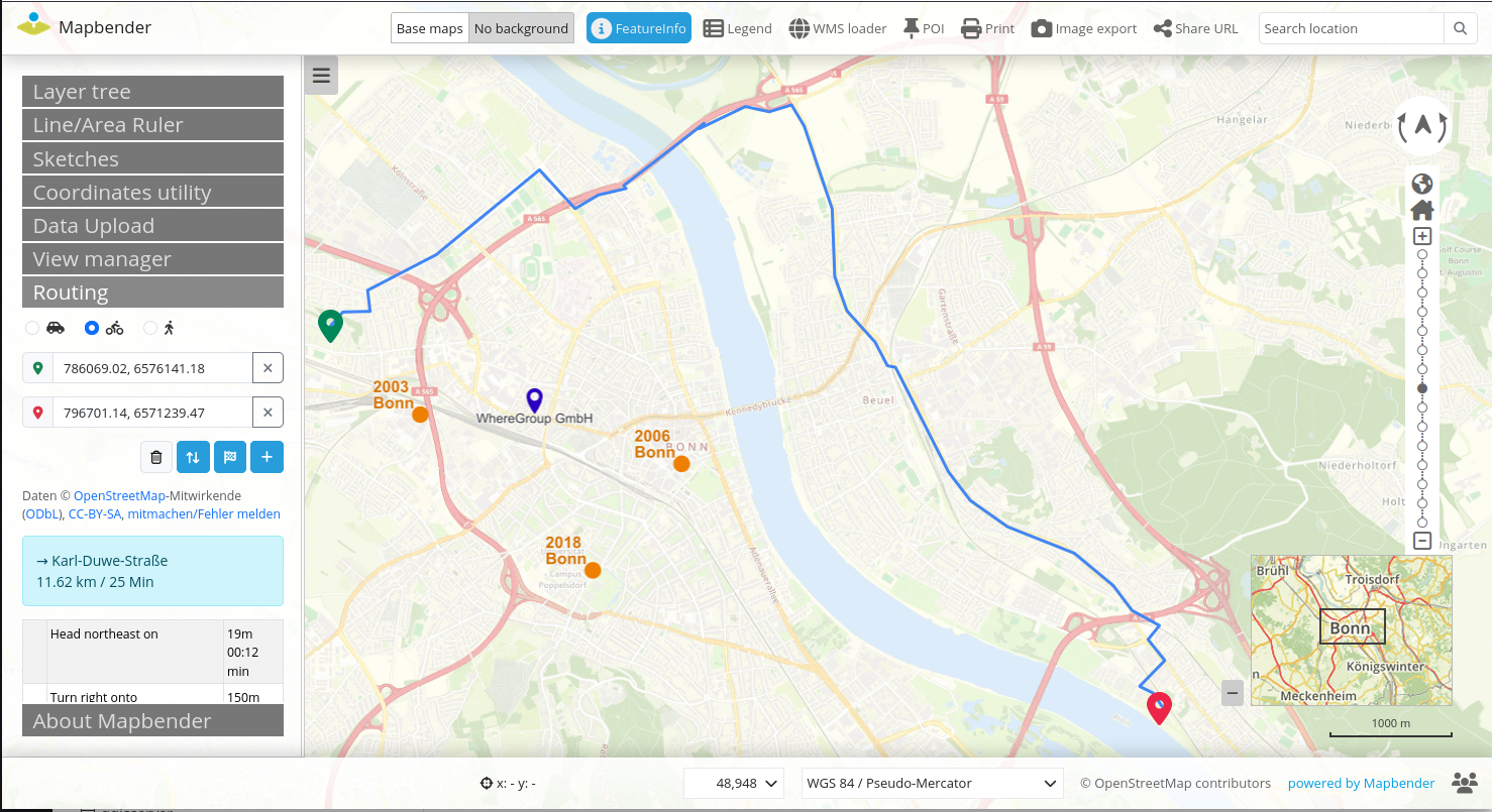
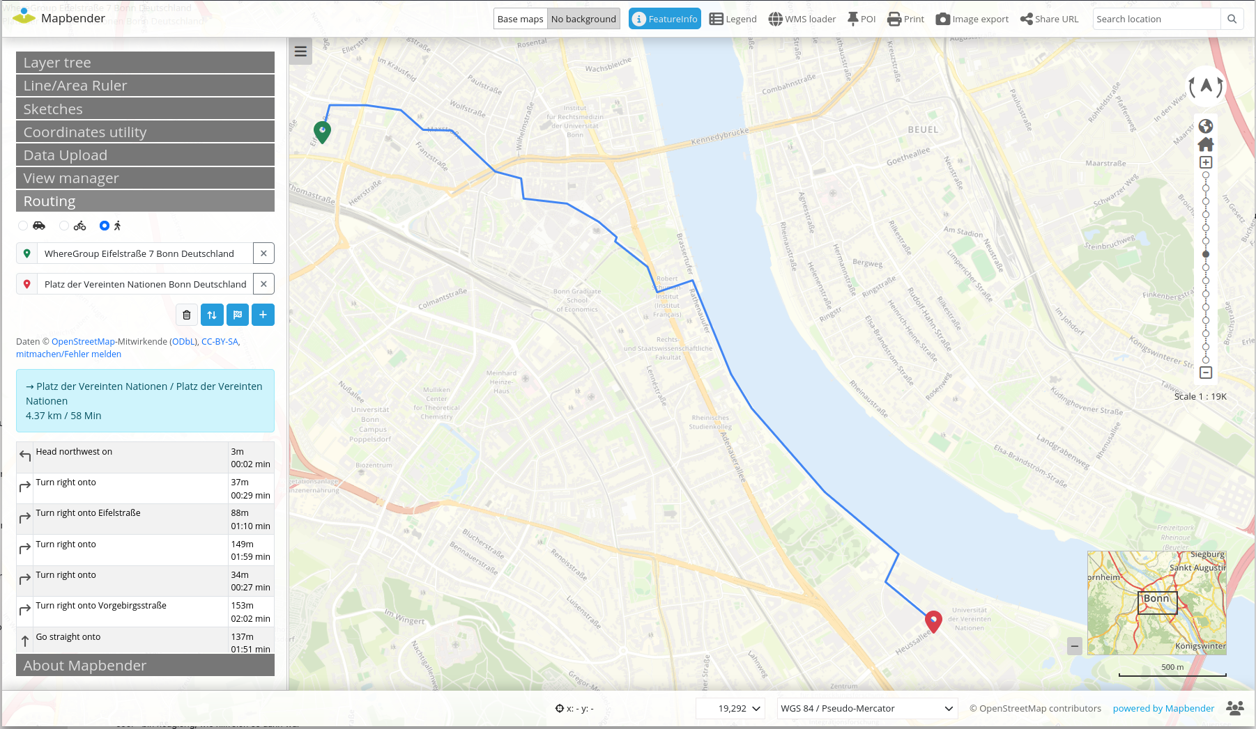
👉🏻 Try the new Routing via OSRM demo.mapbender.org/application
👉🏻 Have a look at the new REST API demo.mapbender.org/doc/api
🚀